The Memorial Hall, building in Shrivenham, Vale of White Horse, Oxfordshire, UK
Posizione: Shrivenham
Coordinate GPS: 51.59813,-1.65827
Ultimo aggiornamento: 25 novembre 2023 alle 01:49
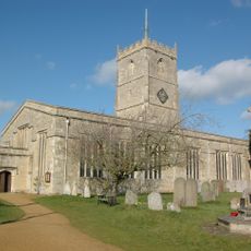
Church of St Andrew
372 m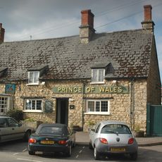
Prince Of Wales Public House
371 m
Jasmine Cottage
327 m
Elm Tree House
299 m
Normanby Cottage
502 m
Oakwood House And The Close
337 m
The White House
262 m
2 And 4, Faringdon Road
523 m
49 And 51, High Street
150 m
13, High Street
426 m
Ivy House
220 m
The Chestnuts
400 m
29 And 31, High Street
309 m
Village School
269 m
40 And 42, High Street
222 m
20, High Street
349 m
44,46 And 48, High Street
204 m
The Cottage
202 m
The Firs
390 m
Fern House
278 m
Church House
414 m
Piers And Gates To East Of The Church Of St Andrew
422 m
Shrivenham House
424 m
Nos. 15 (Dodds Cottage), 17 And 19 (Lilac Cottage)
191 m
8, 10, 14, 18, 24, Claypits Lane
455 m
Old Thatch
135 m
Village Pound Approximately 30 Metres West Of Junction With Fairthorne Way
67 m
1-13, Longcot Road
534 mRecensioni
Ha visitato questo luogo? Tocchi le stelle per valutarlo e condividere la Sua esperienza o foto con la community! Provalo ora! Puoi annullarlo in qualsiasi momento.
Scopri tesori nascosti ad ogni viaggio!
Da piccoli caffè caratteristici a panorami nascosti, fuggi dalla folla e scova i posti che fanno davvero per te. La nostra app ti semplifica tutto: ricerca vocale, filtri furbi, percorsi ottimizzati e dritte autentiche da viaggiatori di tutto il mondo. Scaricala subito per vivere l'avventura sul tuo smartphone!

Un nuovo approccio alla scoperta turistica❞
— Le Figaro
Tutti i luoghi che meritano di essere esplorati❞
— France Info
Un’escursione su misura in pochi clic❞
— 20 Minutes