Heronden, building in Chart Sutton, Maidstone, Kent, UK
Posizione: Chart Sutton
Coordinate GPS: 51.21513,0.56445
Ultimo aggiornamento: 25 novembre 2023 alle 01:32
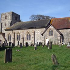
Church of St Michael
1.2 km
Mounting Block About 20 Metres West North West Of Church Of St Michael
1.2 km
Wierton Cottage
1.2 km
Ivy Cottage
396 m
Wierton Hall Farm Cottage
997 m
Garden Gateway About 20 Metres East Of East Hall
858 m
Barn About 56 Metres West Of East Hall
939 m
Barn About 70 Metres West North West Of East Hall
953 m
Wierton Hall
958 m
Old Amber Green Farmhouse
1 km
Tanyard
1.2 km
Former Granary About 15 Metres North Of Chart Place Cottages
1.3 km
Sutton Platt Cottage
1.2 km
Marshalls Place
980 m
The Moorings
1.2 km
Lested Lodge
1.2 km
Rectory Farmhouse
1.2 km
Stable To South Of Rectory Farmhouse
1.2 km
Chart Place
1.2 km
Barn About 40 Metres South South West Of Park House Farmhouse
1.1 km
Wierton Place
1.2 km
House Attached To North Of Post Office Stores
1.1 km
Wierton Grange
1.2 km
East Hall
887 m
Lucks Cottage
714 m
Chart Place Cottages
1.2 km
Ladds Court
456 m
Garden Building To The North-West Of Wierton Place
1.3 kmRecensioni
Ha visitato questo luogo? Tocchi le stelle per valutarlo e condividere la Sua esperienza o foto con la community! Provalo ora! Puoi annullarlo in qualsiasi momento.
Scopri tesori nascosti ad ogni viaggio!
Da piccoli caffè caratteristici a panorami nascosti, fuggi dalla folla e scova i posti che fanno davvero per te. La nostra app ti semplifica tutto: ricerca vocale, filtri furbi, percorsi ottimizzati e dritte autentiche da viaggiatori di tutto il mondo. Scaricala subito per vivere l'avventura sul tuo smartphone!

Un nuovo approccio alla scoperta turistica❞
— Le Figaro
Tutti i luoghi che meritano di essere esplorati❞
— France Info
Un’escursione su misura in pochi clic❞
— 20 Minutes