Bourton Bridge, bridge in Bourton, Vale of White Horse, Oxfordshire, UK
Posizione: Bourton
Coordinate GPS: 51.58612,-1.67275
Ultimo aggiornamento: 25 novembre 2023 alle 01:33
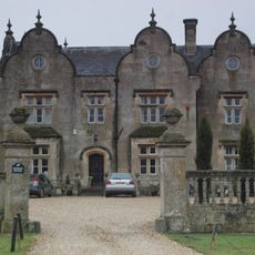
Bourton Grange
251 m
Cowleaze Farmhouse
1.8 km
Elm Tree House
1.9 km
Stallpits Farmhouse
1.6 km
Bourton Grange, Gate Piers And Attached Wall Turning From South East Corner
273 m
Lower Earlscourt Farmhouse
2 km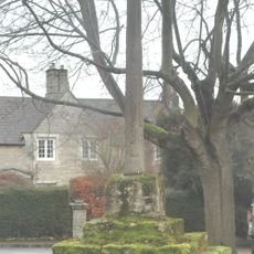
Bourton village cross
695 m
Highlands And The Old Manor House
722 m
The White House
1.9 km
Oakwood House And The Close
1.9 km
Bourton Grange, Gate Piers And Attached Walls Approximately 20 Metres East
273 m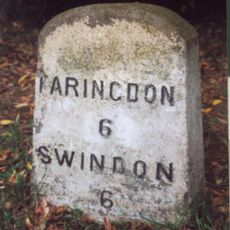
Milestone, Townsend Road; at entrance to Ryme's House
1.1 km
49 And 51, High Street
1.8 km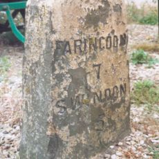
Milestone, by Frenchfields ornamental fish shop (was Acorn End), E of Acorn railway bridge
771 m
Stainswick Farmhouse
1.7 km
Old Thatch
1.8 km
The Memorial Hall
1.7 km
Ivy House
1.8 km
44,46 And 48, High Street
1.8 km
40 And 42, High Street
1.8 km
Nos. 15 (Dodds Cottage), 17 And 19 (Lilac Cottage)
1.8 km
Village Pound Approximately 30 Metres West Of Junction With Fairthorne Way
1.6 km
Village School
1.9 km
29 And 31, High Street
1.9 km
The Cottage
1.5 km
Fern House
1.9 km
Canal Bridge
1.1 km
20, High Street
2 kmRecensioni
Ha visitato questo luogo? Tocchi le stelle per valutarlo e condividere la Sua esperienza o foto con la community! Provalo ora! Puoi annullarlo in qualsiasi momento.
Scopri tesori nascosti ad ogni viaggio!
Da piccoli caffè caratteristici a panorami nascosti, fuggi dalla folla e scova i posti che fanno davvero per te. La nostra app ti semplifica tutto: ricerca vocale, filtri furbi, percorsi ottimizzati e dritte autentiche da viaggiatori di tutto il mondo. Scaricala subito per vivere l'avventura sul tuo smartphone!

Un nuovo approccio alla scoperta turistica❞
— Le Figaro
Tutti i luoghi che meritano di essere esplorati❞
— France Info
Un’escursione su misura in pochi clic❞
— 20 Minutes