·

Attiva posizione

Abbiamo bisogno della tua posizione per mostrarti luoghi interessanti intorno a te

Scopri luoghi nelle vicinanze

Trova luoghi interessanti e gemme nascoste intorno a te

Indicazioni precise

Ottieni indicazioni precise e distanze verso i luoghi

La tua posizione non viene mai condivisa con altri utenti. Viene utilizzata solo quando tocchi il pulsante posizione.

Burton Point

Accedi al tuo account

Inizia a esplorare — è gratis

Scelto da 62.649 viaggiatori nel mondo

Continua con Google
Continua con Apple
o

Ti invieremo un codice per connetterti

Continuando, accetti i nostri Termini e Condizioni e la nostra Informativa sulla Privacy

Controlla la tua casella di posta

Abbiamo inviato un codice PIN nella tua casella di posta. Inserisci il codice qui sotto.

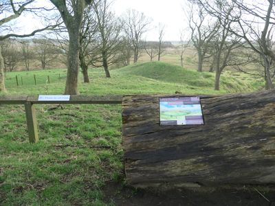
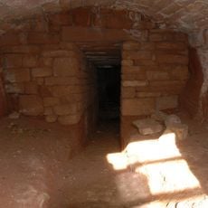
Burton Point, Forte promontorio dell'Età del Ferro nella Penisola di Wirral, Inghilterra

Burton Point è un forte difensivo costruito su un promontorio che domina l'estuario del Dee nel nord-ovest dell'Inghilterra. La struttura utilizza un terrapieno curvo per bloccare l'accesso alla penisola, mentre i pendii naturali offrono protezione aggiuntiva sui lati opposti.

Questo forte fu probabilmente costruito durante l'Età del Ferro come stronghold difensivo in una posizione strategica. All'inizio del 18esimo secolo, un nuovo canale fluviale creato dal lato gallese trasformò il promontorio in territorio senza accesso al mare.

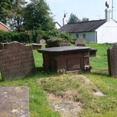
Gli scavi archeologici del 1878 hanno rivelato un cimitero contenente tra 50 e 60 individui, possibilmente collegati alle pratiche cristiane primitive o a un naufragio del 1637.

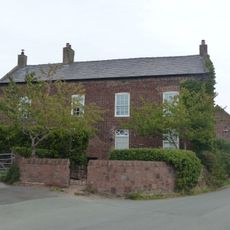
Il sito si trova a sud-ovest di Burton Point Farm e vi si accede a piedi attraverso terreno aperto. Indossare scarpe robuste poiché il terreno è irregolare e può diventare fangoso dopo la pioggia.

Gli scavi nel 1878 hanno rivelato i resti di circa 50 a 60 individui sepolti in questo luogo. Questi reperti potrebbero essere collegati alle pratiche di sepoltura cristiana primitiva o ai sopravvissuti di un naufragio del 1637 nella zona.

La comunità dei viaggiatori curiosi

AroundUs riunisce migliaia di luoghi selezionati, consigli locali e gemme nascoste, arricchiti ogni giorno da oltre 60,000 contributori in tutto il mondo.

Inizia a esplorare
Coordinate GPS
53.25450,-3.04572
Ultimo aggiornamento
14 dicembre 2025 alle 19:20
Intorno a questo luogo
Flintshire Bridge
Regno Unito

Flintshire Bridge

3.2 km
Burton Manor
Regno Unito

Burton Manor

1.3 km
Ness Botanic Gardens
Regno Unito

Ness Botanic Gardens

2 km
St Michael's Church, Shotwick
Regno Unito

St Michael's Church, Shotwick

3.8 km
Shotwick Hall
Regno Unito

Shotwick Hall

3.7 km
St Nicholas' Church, Burton
Regno Unito

St Nicholas' Church, Burton

1.6 km
Old Quay House Inn
Regno Unito

Old Quay House Inn

3.8 km
Front garden walls and gatepiers at Shotwick Hall
Regno Unito

Front garden walls and gatepiers at Shotwick Hall

3.7 km
Tombchest of Robert and Martha Ellison, 10 metres southwest of south corner of tower of Church of St Michael
Regno Unito

Tombchest of Robert and Martha Ellison, 10 metres southwest of south corner of tower of Church of St Michael

3.8 km
Rake Farm Cottage
Regno Unito

Rake Farm Cottage

1.3 km
Bishop Wilson's House
Regno Unito

Bishop Wilson's House

1.3 km
Newstead House
Regno Unito

Newstead House

3.7 km
Former kitchen or bakehouse attached to north east corner of Shotwick Hall
Regno Unito

Former kitchen or bakehouse attached to north east corner of Shotwick Hall

3.7 km
Barn End
Regno Unito

Barn End

1.4 km
K6 Telephone Kiosk In Forecourt Of Post Office (Post Office Not Included)
Regno Unito

K6 Telephone Kiosk In Forecourt Of Post Office (Post Office Not Included)

2.5 km
Plessington Cottage
Regno Unito

Plessington Cottage

1.5 km
Sundial in the churchyard of St Michael
Regno Unito

Sundial in the churchyard of St Michael

3.8 km
Group of 18 chest tombs, approximately 2 metres from the southeast corner of Church of St Nicholas
Regno Unito

Group of 18 chest tombs, approximately 2 metres from the southeast corner of Church of St Nicholas

1.6 km
Tombchest of James Phillips, 2 metres south of the sundial in the Churchyard of St Michael
Regno Unito

Tombchest of James Phillips, 2 metres south of the sundial in the Churchyard of St Michael

3.8 km
Footpath Guidepost At Junction Of Pipers Lane Opposite The White House
Regno Unito

Footpath Guidepost At Junction Of Pipers Lane Opposite The White House

2.5 km
Laburnam Farmhouse And Garden Walls Attached At Front
Regno Unito

Laburnam Farmhouse And Garden Walls Attached At Front

2.5 km
Tombchest of Rev M Reay and 4 children, 8 metres south of south porch of Church of St Michael
Regno Unito

Tombchest of Rev M Reay and 4 children, 8 metres south of south porch of Church of St Michael

3.8 km
Tombchest of John Nevett Bennett, 5 metres west of south porch of St Michael's Church
Regno Unito

Tombchest of John Nevett Bennett, 5 metres west of south porch of St Michael's Church

3.8 km
L-shaped ranges of farm buildings 60 metres north of Shotwick Hall
Regno Unito

L-shaped ranges of farm buildings 60 metres north of Shotwick Hall

3.7 km
Ice house approximately 75 metres south west of Burton Manor
Regno Unito

Ice house approximately 75 metres south west of Burton Manor

1.2 km
Tombchest of William Briscoe (died 1723) and others, 4 metres west of priest's door to St Michael's Church
Regno Unito

Tombchest of William Briscoe (died 1723) and others, 4 metres west of priest's door to St Michael's Church

3.8 km
Tombchest of William Briscoe (died 1704) and others, 5 metres southwest of priest's door to St Michael's Church
Regno Unito

Tombchest of William Briscoe (died 1704) and others, 5 metres southwest of priest's door to St Michael's Church

3.8 km
Goldstraw Farmhouse And Attached Farm Building To North West
Regno Unito

Goldstraw Farmhouse And Attached Farm Building To North West

2.4 km
Mostra la mappa completa
« Burton Point - Forte promontorio dell'Età del Ferro nella Penisola di Wirral, Inghilterra » è fornito da Around Us (it.aroundus.com). Le immagini e i testi sono tratti dal progetto Wikimedia con licenza Creative Commons. È possibile copiare, distribuire e modificare copie di questa pagina, alle condizioni stabilite dalla licenza, a condizione che questa nota sia chiaramente visibile.

Scopri tesori nascosti ad ogni viaggio!

Da piccoli caffè caratteristici a panorami nascosti, fuggi dalla folla e scova i posti che fanno davvero per te. La nostra app ti semplifica tutto: ricerca vocale, filtri furbi, percorsi ottimizzati e dritte autentiche da viaggiatori di tutto il mondo. Scaricala subito per vivere l'avventura sul tuo smartphone!

Around Us App Screenshot

Un nuovo approccio alla scoperta turistica

Le Figaro

Tutti i luoghi che meritano di essere esplorati

France Info

Un’escursione su misura in pochi clic

20 Minutes

Around Us
Guida di viaggio e mappe
Scarica

Invia al tuo telefono

QR Code
1

Apri l'app fotocamera sul tuo cellulare.

2

Inquadra il codice QR con la fotocamera. Apparirà una notifica.

3

Tocca la notifica per aprire il link.