Snagbrook, building in Hollingbourne, Maidstone, Kent, UK
Posizione: Hollingbourne
Coordinate GPS: 51.26390,0.63424
Ultimo aggiornamento: 25 novembre 2023 alle 01:32
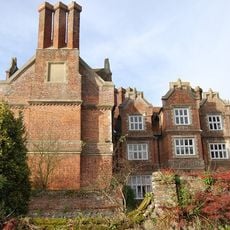
Hollingbourne Manor
594 m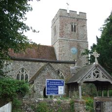
All Saints Church, Hollingbourne
478 m
The Windmill Public House
607 m
Tanyard House
531 m
River Farmhouse
504 m
Godfrey House
200 m
The Old China Shop, Cootage Adjoining To The Right And The Limelet
568 m
50 And 52, Eyhorne Street
563 m
Wimborne House
514 m
The Old Cottage
512 m
57,59,61, Eyhorne Street
543 m
Penn Court
493 m
Table tomb about 2.5 metres east of vestry of Church of All Saints
482 m
Mill House
467 m
64 And 66, Eyhorne Street
513 m
Table tomb to Edward Charlton about 2.5 metres south of Church of All Saints
465 m
Six Bells Cottage
529 m
Table tomb about 22 metres south of Church of All Saints
458 m
Table tomb about 2 metres north of porch of Church of All Saints
483 m
Glyder House Sugar Loaves Public House
553 m
The Old Vicarage
558 m
Table tomb about 6 metres south of Church of All Saints
456 m
Manor Farmhouse
447 m
Grove House
579 m
42-46, Eyhorne Street
580 m
Garden Wall About 3 Metres East Of South Wing Of Hollingbourne Manor
584 m
Table tomb to Richard Thomas about 43 metres south of Church of All Saints
441 m
34-40, Eyhorne Street
595 mRecensioni
Ha visitato questo luogo? Tocchi le stelle per valutarlo e condividere la Sua esperienza o foto con la community! Provalo ora! Puoi annullarlo in qualsiasi momento.
Scopri tesori nascosti ad ogni viaggio!
Da piccoli caffè caratteristici a panorami nascosti, fuggi dalla folla e scova i posti che fanno davvero per te. La nostra app ti semplifica tutto: ricerca vocale, filtri furbi, percorsi ottimizzati e dritte autentiche da viaggiatori di tutto il mondo. Scaricala subito per vivere l'avventura sul tuo smartphone!

Un nuovo approccio alla scoperta turistica❞
— Le Figaro
Tutti i luoghi che meritano di essere esplorati❞
— France Info
Un’escursione su misura in pochi clic❞
— 20 Minutes