
Table tomb to Richard Thomas about 43 metres south of Church of All Saints
Table tomb to Richard Thomas about 43 metres south of Church of All Saints, table tomb in Hollingbourne, Kent, UK
Posizione: Hollingbourne
Coordinate GPS: 51.26472,0.64044
Ultimo aggiornamento: 25 novembre 2023 alle 01:46
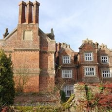
Hollingbourne Manor
250 m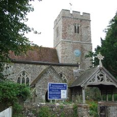
All Saints Church, Hollingbourne
51 m
Bank Cottages
400 m
Wimborne House
943 m
River Farmhouse
929 m
Godfrey House
609 m
Woodgate Yew Trees
382 m
The Old Forge
356 m
The Old Cottage
90 m
Six Bells Cottage
108 m
The Old Vicarage
142 m
Grove House
180 m
Garden Wall About 3 Metres East Of South Wing Of Hollingbourne Manor
227 m
Manor Farmhouse
126 m
Garden Wall About 3 Metre East Of Base Of North Wing Of Hollingbourne Manor
251 m
Penn Court
253 m
Malt Cottage
311 m
Malt House
332 m
The Pilgrims Rest Inn
352 m
Mill House
142 m
Forge Cottages
361 m
Hollingbourne War Memorial
367 m
Table tomb about 2 metres north of porch of Church of All Saints
67 m
Table tomb about 2.5 metres east of vestry of Church of All Saints
46 m
Snagbrook
441 m
Table tomb to Edward Charlton about 2.5 metres south of Church of All Saints
37 m
Table tomb about 6 metres south of Church of All Saints
30 m
64 And 66, Eyhorne Street
932 mRecensioni
Ha visitato questo luogo? Tocchi le stelle per valutarlo e condividere la Sua esperienza o foto con la community! Provalo ora! Puoi annullarlo in qualsiasi momento.
Scopri tesori nascosti ad ogni viaggio!
Da piccoli caffè caratteristici a panorami nascosti, fuggi dalla folla e scova i posti che fanno davvero per te. La nostra app ti semplifica tutto: ricerca vocale, filtri furbi, percorsi ottimizzati e dritte autentiche da viaggiatori di tutto il mondo. Scaricala subito per vivere l'avventura sul tuo smartphone!

Un nuovo approccio alla scoperta turistica❞
— Le Figaro
Tutti i luoghi che meritano di essere esplorati❞
— France Info
Un’escursione su misura in pochi clic❞
— 20 Minutes