
Table tomb about 6 metres south of Church of All Saints
Table tomb about 6 metres south of Church of All Saints, table tomb in Hollingbourne, Kent, UK
Posizione: Hollingbourne
Coordinate GPS: 51.26498,0.64055
Ultimo aggiornamento: 25 novembre 2023 alle 01:46
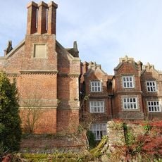
Hollingbourne Manor
220 m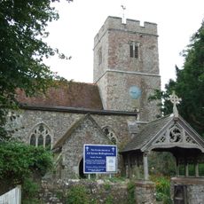
All Saints Church, Hollingbourne
24 m
Bank Cottages
371 m
Wimborne House
962 m
River Farmhouse
948 m
Godfrey House
628 m
Woodgate Yew Trees
352 m
The Old Forge
327 m
The Old Cottage
63 m
Six Bells Cottage
81 m
Mill House
115 m
Grove House
152 m
Garden Wall About 3 Metres East Of South Wing Of Hollingbourne Manor
197 m
Manor Farmhouse
102 m
Garden Wall About 3 Metre East Of Base Of North Wing Of Hollingbourne Manor
221 m
Penn Court
228 m
Malt Cottage
282 m
Malt House
303 m
The Pilgrims Rest Inn
324 m
The Old Vicarage
115 m
Forge Cottages
331 m
Table tomb about 2 metres north of porch of Church of All Saints
38 m
Table tomb to Richard Thomas about 43 metres south of Church of All Saints
30 m
Hollingbourne War Memorial
386 m
Snagbrook
456 m
Table tomb about 2.5 metres east of vestry of Church of All Saints
28 m
Table tomb about 22 metres south of Church of All Saints
17 m
64 And 66, Eyhorne Street
951 mRecensioni
Ha visitato questo luogo? Tocchi le stelle per valutarlo e condividere la Sua esperienza o foto con la community! Provalo ora! Puoi annullarlo in qualsiasi momento.
Scopri tesori nascosti ad ogni viaggio!
Da piccoli caffè caratteristici a panorami nascosti, fuggi dalla folla e scova i posti che fanno davvero per te. La nostra app ti semplifica tutto: ricerca vocale, filtri furbi, percorsi ottimizzati e dritte autentiche da viaggiatori di tutto il mondo. Scaricala subito per vivere l'avventura sul tuo smartphone!

Un nuovo approccio alla scoperta turistica❞
— Le Figaro
Tutti i luoghi che meritano di essere esplorati❞
— France Info
Un’escursione su misura in pochi clic❞
— 20 Minutes